
Where to rock: a geology field guide
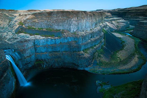
Palouse Falls illustrates geological features unique to the Inland Northwest.
January 20, 2015
Hiking, driving, jazzercising… however students get around the Palouse, they’re bound to pass one of the area’s many unique rock formations.
Kurtis Wilkie, WSU School of the Environment instructor, said one unique kind of rock people often pass by without noticing it are pillow basalts. These rounded, pillow-shaped rocks are surrounded by a bright yellow shell and found along Highway 26, he said. Their shape and color comes from when the basalt came in contact with water, which cooled it rapidly to form a glass that breaks off to form a new mineral, he said.
“Anyone who drives 26 has passed miles of these,” Wilkie said.
Most students traveling from Seattle to Pullman drive Highway 26 through Washtucna, he said. But many students don’t know that just a few miles south of Washtucna is the waterfall Palouse Falls, he said.
Wilkie said he usually takes his geology classes to visit once a semester, and there are paths to viewpoints from the top and the bottom of the falls. He also said to be aware that Palouse Falls is in a state park and passes are needed to park there.
“I then take them to Starbuck, it’s not a place to drink coffee,” Wilkie said. “It’s a location where the Snake River and the Columbia, when they backed up, they forced water upstream and they left certain types of deposits, which we can recognize as flood deposits.”
The Missoula flood, which occurred at the end of the last ice age, was a glacial dam that broke and poured the equivalent of one of the great lakes forth, he said. The massive amount of water had enough volume and force to make the Snake River flow backward and even form the Palouse Falls.
“The whole feature itself was carved out by the Missoula flood,” John Wolff said, professor and associate director at the WSU School of the Environment.
He said it can be hard to imagine the massive scale of some geographic events. The YouTube videos of hot lava flows in Hawaii are nothing like what made the Columbia River Basalts 16 million years ago. Those lava flows covered from Pullman to the coast, he said.
“The sheer scale has never been repeated in history,” Wolff said.
Peter Larson, WSU School of the Environment professor, said layers of volcanic rock can be seen on the road to Lewiston. Visible float tops and float bottoms run parallel to the road, and different red zones are visible to the geology novice.
“There’s a great deal of geological history revealed in the drive,” Larson said.
He said the Wallowa Mountains near Enterprise, Oregon, are a day trip away but one of his favorite geographic spots. He said the little-known peaks are glaciated and beautiful; however, he is a little topographically biased.
“I’m a mountain person, not a river person,” he said.
Kamiak Butte and Steptoe Butte are both within an hour’s drive of Pullman. Kamiak Butte has plenty of hiking trails, and people can drive to the top of Steptoe Butte, Wilkie said.
Look for recognizable rock formations on your hike.
The rocks found at both buttes are Precambrian sandstones, Larson said.
“Precambrian is old stuff,” he said. “I’m not quite sure what age they are, but I think they’re about 1.3 to 1.4 billion-year-old sediments.”
The WSU School of the Environment’s website features several geological road trips to see rocks a little closer to Pullman. Field trip guides show where the rocks are located with maps highlighting all the stops and explanations behind the geological features there. Those interested can download guides under the Geology Field Guides tab on the School of the Environment’s website.